Boundary Line Adjustment Surveys
Whether you’re a homeowner or developer, Holt Gilmour is your trusted partner for boundary line adjustment services in Vermont, New Hampshire, New York, and throughout the northeast. Our team of experienced, licensed surveyors delivers accurate and precise results and seamless adjustments through our attention to detail and dedication to going above and beyond for our clients.
What is a boundary line adjustment survey?
A boundary line adjustment survey (also known as a lot line adjustment) is a process for adjusting property lines between two adjoining properties. To perform this service, a full or partial boundary survey must first be completed.
Learn about boundary surveys
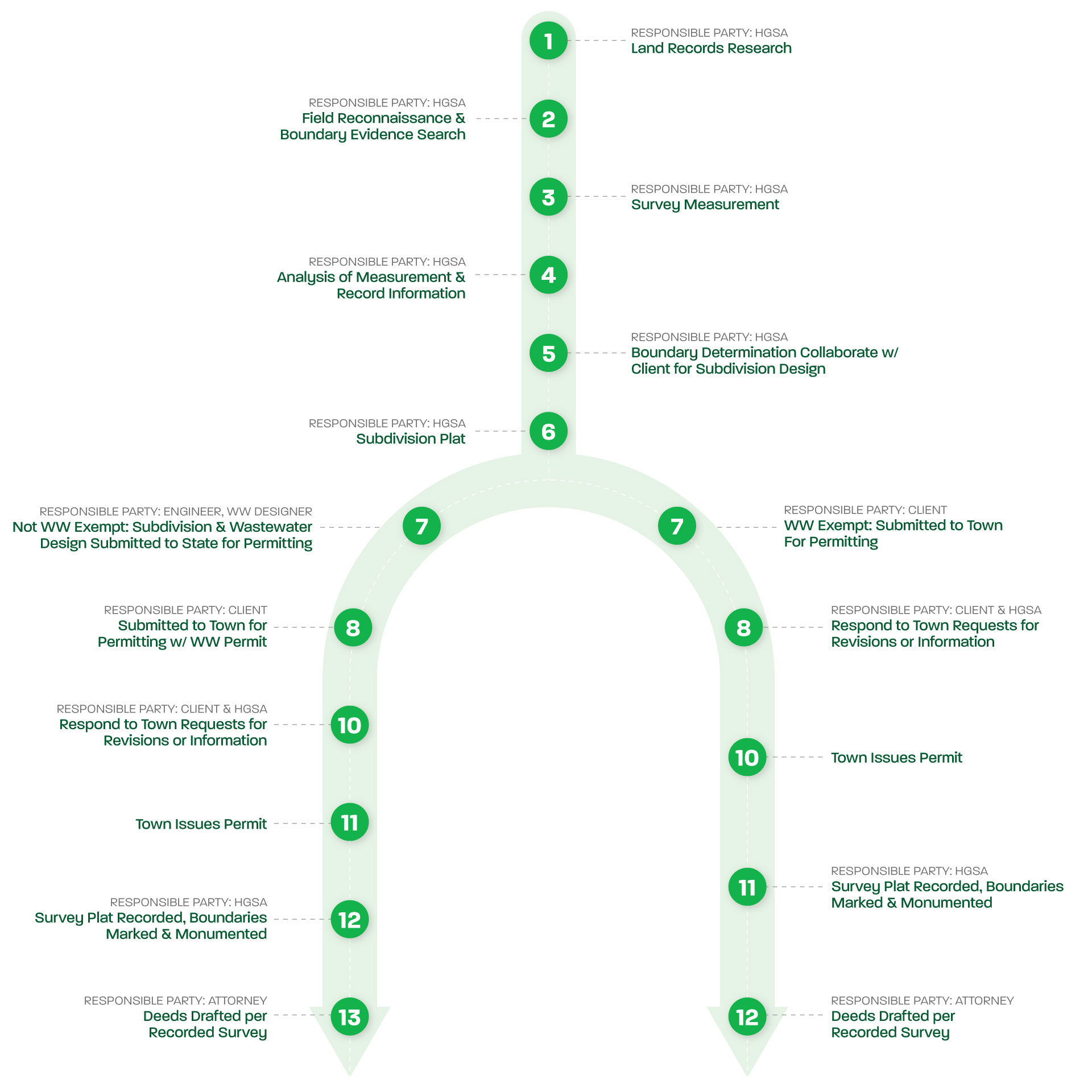
As licensed surveyors, we ensure accurate delineation and alignment of property boundaries according to legal requirements and agreements between parties. This survey typically involves measuring existing boundary lines, analyzing legal descriptions, and considering any applicable zoning regulations or property restrictions. The survey results are then documented on a plat, which will be submitted to the town or local jurisdiction for approval and recording. Boundary line adjustment surveys play a crucial role in maintaining the integrity and clarity of property boundaries, providing peace of mind to landowners, and facilitating smooth land transactions.
Boundary line adjustment survey process

Reasons for a boundary line adjustment survey
The purpose of a boundary line adjustment survey is to resolve discrepancies or uncertainties in property boundaries, often due to changes in land use or ownership over time. It is often sought by property owners when they desire to exchange, gift, or sell a portion of their land to a neighbor, or acquire a portion of a neighbors’ land. This type of survey is often required to merge adjoining parcels into one, increase the size of a lot, reduce the size of a lot, or change lot dimensions to meet zoning requirements. A boundary line adjustment is distinct from a subdivision in that it does not result in any new parcels.
By clarifying and adjusting the boundary lines, property owners can avoid potential disputes and ensure a clear title to their land.
Boundary line agreements
In some instances, uncertainties and disputes over boundary lines can be resolved with a Boundary Line Agreement. It is often sought by property owners and neighbors when they disagree about exact property lines or there is significant uncertainty about the location of boundaries. This can offer a more straightforward path to delineating shared boundaries between property owners. It’s also more economical because there’s often no need for extensive land records research and recovery of physical evidence.
During a Boundary Line Agreement service, both landowners will show us the mutually agreed upon boundary line, and all parties will sign the survey plat detailing the new boundaries.
FAQs
A: The cost of a surveydepends on a variety of factors: the reason for the survey, the size and shape of the property, and the scope of the work. We can provide services à la carte (research and/or measurement, drafting, etc.), but some services require others to be rendered (we can’t set monuments without recording a survey plat in the land records, measurement is necessary to produce a survey plat, etc.). We provide fixed pricing. If unforeseen circumstances arise, we only proceed with additional work above the fixed price with client approval.
Related Services
Need a land surveying partner?
Let us be your partner for all your land surveying needs. We can help determine if—and when—you need a survey, and which services are right for you.


