• Skip to primary navigation
  • Skip to main content
Holt Gilmour Survey Associates

Holt Gilmour Survey Associates

Your survey needs: met.

  • For Landowners
    • Boundary Surveys
    • Subdivision Surveys
    • Boundary Line Adjustment Surveys
    • Flood Elevation Surveys
    • Topographic Surveys & Site Plans
    • Condominium Surveys
    • Easement Surveys
  • For Professionals
  • About Us
  • Contact

Subdivision Surveys

Topographic Surveys & Site Plans

Topographic Surveys & Site Plans

If you need a professional topographic survey in Vermont, New Hampshire, New York, or anywhere in the Northeast, the team at Holt Gilmour Associates can help. Our land surveyors are experts who use state-of-the-art technology to produce accurate and detailed topographic maps to help keep projects on schedule and on budget.

What is a topographic survey?

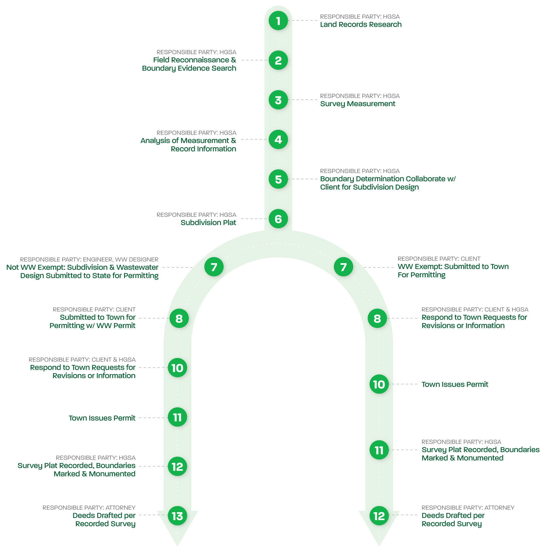
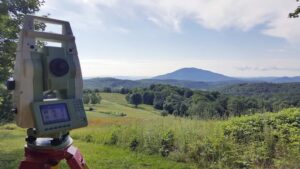
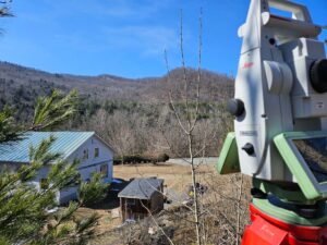
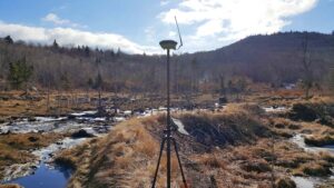
Topographic Surveys are detailed maps of the features of a property. They may include contours, slopes, and other physical attributes like structures, utilities, roads, driveways, bodies of water, boulders, and trees. These surveys are accomplished using specialized technology that directly measures the elevations and features of a property or site. These elevations and features are then represented on a site plan, or a map, that precisely displays the property’s contour lines and attributes.

Reasons for a topographic survey or site plan

Topographic Surveys are useful tools for land developers, designers, engineers, and construction crews, and are often sought for the purposes of planning and designing houses, additions, roads, and driveways. Engineers and architects often utilize topographic site plans to complete their design work for a client, as these tools allow them to easily visualize the land and its features. Federal, state, and local government municipalities also use topographic reports when creating or enforcing zoning regulations.

Related Services

  • worker surveying house

    Boundary Surveys

  • Subdivision Surveys

  • Antique wheels in woods

    Boundary Line Adjustment Surveys

  • survey equipment in wetland

    Flood Elevation Surveys

  • workers looking at survey equipment

    Condominium Surveys

Need a land surveying partner?

Let us be your partner for all your land surveying needs. We can help determine if—and when—you need a survey, and which services are right for you.

Contact Us
Holt Gilmour Survey Associates

Serving Vermont, New Hampshire, New York & the Northeast

Holt Gilmour Survey Associates
(802) 457-4649

Locations

Woodstock
PO Box 544
51 Pleasant Street
Woodstock, VT 05091
(802) 457-4649

Williston
PO Box 1261
Williston, VT 05495
(802) 457-4649 

Quick Links

For Landowners

For Professionals

Contact Us

Copyright © 2025 Holt Gilmour Survey Associates – All Rights Reserved – Website by Stride Creative Group

Boundary Line Adjustment Surveys

Boundary Line Adjustment Surveys

Whether you’re a homeowner or developer, Holt Gilmour is your trusted partner for boundary line adjustment services in Vermont, New Hampshire, New York, and throughout the northeast. Our team of experienced, licensed surveyors delivers accurate and precise results and seamless adjustments through our attention to detail and dedication to going above and beyond for our clients.

What is a boundary line adjustment survey?

A boundary line adjustment survey (also known as a lot line adjustment) is a process for adjusting property lines between two adjoining properties. To perform this service, a full or partial boundary survey must first be completed.
Learn about boundary surveys

As licensed surveyors, we ensure accurate delineation and alignment of property boundaries according to legal requirements and agreements between parties. This survey typically involves measuring existing boundary lines, analyzing legal descriptions, and considering any applicable zoning regulations or property restrictions. The survey results are then documented on a plat, which will be submitted to the town or local jurisdiction for approval and recording. Boundary line adjustment surveys play a crucial role in maintaining the integrity and clarity of property boundaries, providing peace of mind to landowners, and facilitating smooth land transactions.

Boundary line adjustment survey process

Boundary Line Adjustment Survey Process

Reasons for a boundary line adjustment survey

The purpose of a boundary line adjustment survey is to resolve discrepancies or uncertainties in property boundaries, often due to changes in land use or ownership over time. It is often sought by property owners when they desire to exchange, gift, or sell a portion of their land to a neighbor, or acquire a portion of a neighbors’ land. This type of survey is often required to merge adjoining parcels into one, increase the size of a lot, reduce the size of a lot, or change lot dimensions to meet zoning requirements. A boundary line adjustment is distinct from a subdivision in that it does not result in any new parcels.

By clarifying and adjusting the boundary lines, property owners can avoid potential disputes and ensure a clear title to their land.

Boundary line agreements

In some instances, uncertainties and disputes over boundary lines can be resolved with a Boundary Line Agreement. It is often sought by property owners and neighbors when they disagree about exact property lines or there is significant uncertainty about the location of boundaries. This can offer a more straightforward path to delineating shared boundaries between property owners. It’s also more economical because there’s often no need for extensive land records research and recovery of physical evidence.

During a Boundary Line Agreement service, both landowners will show us the mutually agreed upon boundary line, and all parties will sign the survey plat detailing the new boundaries.

FAQs

Q: How much does a boundary survey cost? 

A: The cost of a surveydepends on a variety of factors: the reason for the survey, the size and shape of the property, and the scope of the work. We can provide services à la carte (research and/or measurement, drafting, etc.), but some services require others to be rendered (we can’t set monuments without recording a survey plat in the land records, measurement is necessary to produce a survey plat, etc.).  We provide fixed pricing. If unforeseen circumstances arise, we only proceed with additional work above the fixed price with client approval. 

Q: Can I proceed with my project without a boundary survey?

A: If undertaking a project that requires a permit, many towns will accept a homemade plan/map/sketch for the initial stages of the permitting process. A survey performed by a licensed land surveyor is required by most municipalities to finalize the permitting process. Having a completed survey from the beginning of the process will save time in the long run.

Q: Is a boundary survey required during a real estate transaction?

A: Having a boundary survey performed when buying or selling land will make the process much smoother and address any issues long before a closing date.

Q: Why do I need a boundary survey if my property has been surveyed in the past?

A: A boundary survey represents the location of the boundaries at the time the survey was conducted. This is based on a set of facts and evidence that were available at that time. Over time, neighbors change and boundary evidence and corner markers become lost or overgrown. As properties are conveyed, deed descriptions are not always consistent—they may contain errors that affect your property or omit important information, such as the rights of others on your land or your rights on others’ land. A current survey will bring all this information up to date, reflect the current state of the property, and delineate the boundaries based on the most current information. 

Q: Do you survey in the winter?

A: Yes,we survey year-round.

Related Services

  • worker surveying house

    Boundary Surveys

  • Subdivision Surveys

  • equipment close up with mountain view

    Topographic Surveys & Site Plans

Need a land surveying partner?

Let us be your partner for all your land surveying needs. We can help determine if—and when—you need a survey, and which services are right for you.

Contact Us
Holt Gilmour Survey Associates

Serving Vermont, New Hampshire, New York & the Northeast

Holt Gilmour Survey Associates
(802) 457-4649

Locations

Woodstock
PO Box 544
51 Pleasant Street
Woodstock, VT 05091
(802) 457-4649

Williston
PO Box 1261
Williston, VT 05495
(802) 457-4649 

Quick Links

For Landowners

For Professionals

Contact Us

Copyright © 2025 Holt Gilmour Survey Associates – All Rights Reserved – Website by Stride Creative Group

Boundary Surveys

Boundary Surveys

As specialists in land surveying, we perform various types of boundary survey services for residential and commercial property owners and managers in Vermont, New Hampshire, New York, and throughout the northeast. We’re experts in boundary law, land record research, and measurement—providing the highest standards of practice, compliance, and diligence to achieve accurate results.

What is a boundary survey?

Also known as boundary retracement surveys, boundary surveys are used to determine actual boundary lines and corners of an existing property. This process involves intensive land records research, searching for existing physical boundary evidence, measurement, drafting a plat (a map with dimensions of the property), and marking the legally defensible boundaries.

1. Research

We perform exhaustive research of the property, leaving no stone unturned. This includes locating and reading deeds and previous ownership documents, previously completed surveys, and other historical documents that inform our research—sometimes dating back to the 18th century. We perform this same research for all adjacent properties.

2. Boundary evidence recovery

Also called field reconnaissance, boundary evidence recovery combines our research and all available physical evidence on the property to create a map showing the boundary dimensions called for in the land records. This may involve searching for boundary evidence with magnetic locators, survey-grade GPS, and a variety of other tools for accuracy, precision, and efficiency.

3. Field measurement

Using sophisticated measuring equipment and control methods to ensure thorough and precise data, we perform measurements around the property to obtain the survey data needed to make legally defensible boundary determinations and draft a plat.

4. Plat drafting

Along with aerial imagery, topographic data, historical records, historical maps, and GIS data, we import our own measurement data into AutoCAD drafting software to analyze all the information available to us.  We can provide PDF, full-size paper, mylar, .shp shapefile, .dwg drawing file, and almost any other GIS and AutoCAD deliverables.

5. Monumentation

We set new survey monuments to permanently mark the boundaries. At our client’s discretion, these can range from 5/8”x30” rebar to locking aluminum rods with granite bounds.  All monuments are capped with aluminum or bronze identifying caps with our license number.

Reasons for a boundary survey

Boundary surveys are performed when homeowners or property managers need to establish where their existing boundaries are. This enables them to identify or clarify the property rights of themselves or others. Clients often request boundary surveys for the following reasons:

  • To provide a clear property description in a deed when selling, buying, or gifting land
  • To prove compliance with zoning requirements when building a new structure or an addition
  • When conserving land
  • When undertaking utility projects, like pipelines, water, sewer, etc.
  • To establish or relinquish easements (rights of way, etc.)
  • To determine a responsible party when their property is impacted by environmental contamination
  • To install a fence
  • To undergo a construction project
  • To settle a dispute with a neighbor or to avoid encroachment to or by a neighbor

FAQs

Q: How much does a boundary survey cost? 

A: The cost of a surveydepends on a variety of factors: the reason for the survey, the size and shape of the property, and the scope of the work. We can provide services à la carte (research and/or measurement, drafting, etc.), but some services require others to be rendered (we can’t set monuments without recording a survey plat in the land records, measurement is necessary to produce a survey plat, etc.).  We provide fixed pricing. If unforeseen circumstances arise, we only proceed with additional work above the fixed price with client approval. 

Q: Can I proceed with my project without a boundary survey?

A: If undertaking a project that requires a permit, many towns will accept a homemade plan/map/sketch for the initial stages of the permitting process. A survey performed by a licensed land surveyor is required by most municipalities to finalize the permitting process. Having a completed survey from the beginning of the process will save time in the long run. 

Q: Is a boundary survey required during a real estate transaction?

A: Having a boundary survey performed when buying or selling land will make the process much smoother and address any issues long before a closing date.

Q: Why do I need a boundary survey if my property has been surveyed in the past?

A: A boundary survey represents the location of the boundaries at the time the survey was conducted. This is based on a set of facts and evidence that were available at that time. Over time, neighbors change and boundary evidence and corner markers become lost or overgrown. As properties are conveyed, deed descriptions are not always consistent—they may contain errors that affect your property or omit important information, such as the rights of others on your land or your rights on others’ land. A current survey will bring all this information up to date, reflect the current state of the property, and delineate the boundaries based on the most current information. 

Q: Do you survey in the winter?

A: Yes,we survey year-round.

Related Services

  • worker surveying house

    Boundary Surveys

  • Subdivision Surveys

  • equipment close up with mountain view

    Topographic Surveys & Site Plans

Need a land surveying partner?

Let us be your partner for all your land surveying needs. We can help determine if—and when—you need a survey, and which services are right for you.

Contact Us
Holt Gilmour Survey Associates

Serving Vermont, New Hampshire, New York & the Northeast

Holt Gilmour Survey Associates
(802) 457-4649

Locations

Woodstock
PO Box 544
51 Pleasant Street
Woodstock, VT 05091
(802) 457-4649

Williston
PO Box 1261
Williston, VT 05495
(802) 457-4649 

Quick Links

For Landowners

For Professionals

Contact Us

Copyright © 2025 Holt Gilmour Survey Associates – All Rights Reserved – Website by Stride Creative Group

Copyright © 2025 Holt Gilmour Survey Associates – Website by Stride Creative Group